


.jpg)


Coleraine Walks
Highway to Health TrailIf you want to see a bit of Coleraine and keep fit at the same time try the Highway to Health Trail, starting at Coleraine Leisure Centre which can be walked in approximately 35 minutes and is suitable for people of all ages.
The Trim Trail The Trim Trail at Somerset Forest combines a forest walk with exercise challenges.
Christie Park and Somerset Riverside Park
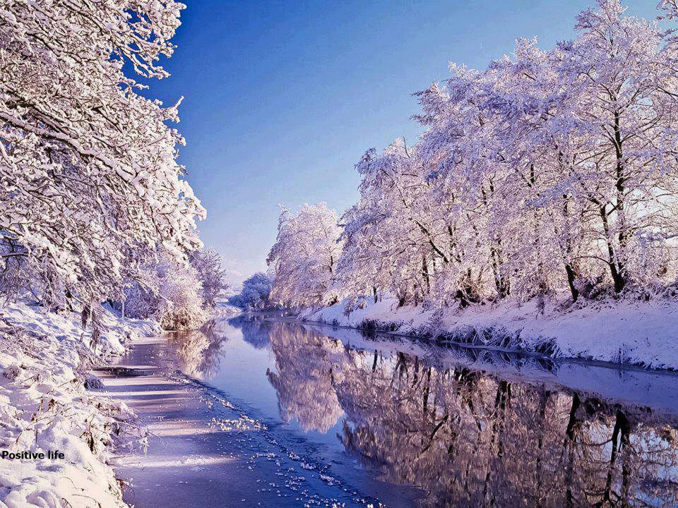
Placed between Coleraine's two bridges, Christie Park has a spectacular location, with great views across the Bann. It's a real oasis of calm only a few minutes from the bustle of the Town centre. There is a free car park and public toilets, accessible from Strand Road.
Placed between Coleraine's two bridges, Christie Park has a spectacular location, with great views across the Bann. It's a real oasis of calm only a few minutes from the bustle of the Town centre. There is a free car park and public toilets, accessible from Strand Road.
Boat trips of the River Bann depart from Christie Park on a seasonal basis, seewww.riverbanncruises.com for details. It's a good place to start the Health Walk. As you walk beside the river, you can enjoy looking at the wide variety of trees and flowers, feeding the swans or simply admiring the view.
The riverside walk can be extended by passing underneath the new bridge and entering Somerset Riverside Park, a linear park with more of a countryside feel than Christie Park. Keep an eye open for cormorants on the river, songbirds in the trees and wildflowers at your feet.
Mountsandel Forest
A mature mixed woodland overlooking the River Bann, Mountsandel Forest contains the oldest known human settlement in Ireland. Dating from Mesolithic times - 7000 years B.C. - the excavation site is found next to the fort. There are panoramic views of the Bann which reflect the earlier importance of this area. The forest walk goes from a high point at the fort down to the banks of the Bann, and passes close to the weir at the Cutts.
A mature mixed woodland overlooking the River Bann, Mountsandel Forest contains the oldest known human settlement in Ireland. Dating from Mesolithic times - 7000 years B.C. - the excavation site is found next to the fort. There are panoramic views of the Bann which reflect the earlier importance of this area. The forest walk goes from a high point at the fort down to the banks of the Bann, and passes close to the weir at the Cutts.
Anderson Park
Situated in the centre of Coleraine, this attractively landscaped park includes an impressive children's adventure playground suitable for children of all ages.
Situated in the centre of Coleraine, this attractively landscaped park includes an impressive children's adventure playground suitable for children of all ages.
Anderson Park runs in three sections from the town ramparts to the River Bann. It is named after Hugh Anderson Esq. J.P, who in 1899 bequeathed £3,000 to the people of Coleraine to provide the park. The land for the park was given to the town by William Thomas Church and The Hon. Irish Society.
Coleraine's Historical Town Trail
Interesting Town and Country based trails are located in and around Coleraine. These walks feature many sites of historical, architectural or local significance. Maps can be obtained from the Council Offices, or at the Tourist Information Centre in Coleraine.
Interesting Town and Country based trails are located in and around Coleraine. These walks feature many sites of historical, architectural or local significance. Maps can be obtained from the Council Offices, or at the Tourist Information Centre in Coleraine.
• 1. The Diamond
The central square of the town, a focal point laid out in 1610. A Town Hall has stood here since 1743.
The central square of the town, a focal point laid out in 1610. A Town Hall has stood here since 1743.
• 2. St Patrick's ChurchTraditionally the site of the early Christian Church founded by St Patrick in the 5th century AD. Used continuously for worship since medieval times. The present church contains fine 17th century monuments.
• 3. Church Street
Birthplace and home of Hugh Thompson, whose artistic abilities led him to become chief illustrator for Macmillan's, the London publishers, in the late 1800s.
Birthplace and home of Hugh Thompson, whose artistic abilities led him to become chief illustrator for Macmillan's, the London publishers, in the late 1800s.
• 4. New Row
One of the original Plantation streets, formerly the site of Ulster's oldest surviving town house, built in 1674, and now standing in the Ulster Folk Museum. The Coleraine street plan was established by 1611, and remains of houses built then may still be found hidden by later buildings.
One of the original Plantation streets, formerly the site of Ulster's oldest surviving town house, built in 1674, and now standing in the Ulster Folk Museum. The Coleraine street plan was established by 1611, and remains of houses built then may still be found hidden by later buildings.
• 5. Beresford's House
Some of the 1611 New Row houses survived intact into the 19th century. Each house, only 16 feet wide and 23 feet long, contained two ground floor rooms. Sir Tristram Beresford, of the prominent Coleraine family, is believed to have lived here.
Some of the 1611 New Row houses survived intact into the 19th century. Each house, only 16 feet wide and 23 feet long, contained two ground floor rooms. Sir Tristram Beresford, of the prominent Coleraine family, is believed to have lived here.
• 6. The Old Gaol
Site near Bind Gate in the late 1800s.
Site near Bind Gate in the late 1800s.
• 7. Blind Gate
The south gate of the town, similar to King's Gate.
The south gate of the town, similar to King's Gate.
• 8. Presbyterian Manse
Briefly the residence of Bonar Law, British Prime Minister, subsequently used as a library and youth centre.
Briefly the residence of Bonar Law, British Prime Minister, subsequently used as a library and youth centre.
• 9. Old Limekiln
The Bann side in the early 17th century was a scene of great industry. A limekiln, brickyards and timber stores supplied building materials for the new town.
The Bann side in the early 17th century was a scene of great industry. A limekiln, brickyards and timber stores supplied building materials for the new town.
• 10. The Boat House
Built in 1900, architect W J Given of Coleraine. The lower storey is of Belfast brick, the upper is half-timbered.
Built in 1900, architect W J Given of Coleraine. The lower storey is of Belfast brick, the upper is half-timbered.
• 11. The site of the Dominican Abbey
Founded as St Mary's in 1244, dissolved in the 1530s. Sir Thomas Phillips, one of the founders of modern Coleraine, converted it to a townhouse.
Founded as St Mary's in 1244, dissolved in the 1530s. Sir Thomas Phillips, one of the founders of modern Coleraine, converted it to a townhouse.
• 12. The old Trustee Savings BankStanding in Abbey Street, it still declares 'The hand of the diligent maketh rich' on wall tiles.
• 13. The old Customs House
Now a shop, but still preserving its original fanlight, doorway and bay. Once the home of Thomas Allingham (1824-1889), poet and customs officer.
• 14. Bann Bridge
The earliest bridge was of timber, built around 1248, but until the present bridge was built in 1844, the Bann was for centuries crossed by ferry (hence Ferryquay Street).
• 15. The River Bann
Reputedly named after the goddess Banda some 2000 years ago, the river has carried prehistoric man, early missionaries, Vikings, Normans and 17th century settlers. Famous for its yields of salmon and eels, the salmon can be seen at 'the Leap' in June.
Reputedly named after the goddess Banda some 2000 years ago, the river has carried prehistoric man, early missionaries, Vikings, Normans and 17th century settlers. Famous for its yields of salmon and eels, the salmon can be seen at 'the Leap' in June.
• 16. Clothworkers Hotel
Built on the site of a medieval castle, the building, now shops and offices, gives the impression of guarding the west end of the bridge.
Built on the site of a medieval castle, the building, now shops and offices, gives the impression of guarding the west end of the bridge.
• 17. Methodist Church
Built in 1854, with a fine classical facade.
Built in 1854, with a fine classical facade.
• 18. The North Rampart
Part of Coleraine's 17th century town defences, still visible behind St Patrick's church.
Part of Coleraine's 17th century town defences, still visible behind St Patrick's church.
• 19. Anderson Park
Donated to the town by Hugh Anderson, the park contains a fine cast iron memorial fountain, dated 1911.
Donated to the town by Hugh Anderson, the park contains a fine cast iron memorial fountain, dated 1911.
• 20. Watermill
Possibly the site of the 1350s 'mill of Coulrath', more recently the site of the 1620s watermill.
Possibly the site of the 1350s 'mill of Coulrath', more recently the site of the 1620s watermill.
• 21. Site of King's Gate
The gate was 12 feet wide with a wooden guardhouse above. A drawbridge spanned an outer defensive moat.
The gate was 12 feet wide with a wooden guardhouse above. A drawbridge spanned an outer defensive moat.
• 22. The East Ramparts
Built in 1611 of earth and stone, with an outer moat 8 feet deep. The line of the defences is followed by Society Street, once known as 'The Ramparts'.
Built in 1611 of earth and stone, with an outer moat 8 feet deep. The line of the defences is followed by Society Street, once known as 'The Ramparts'.
• 23. The Markets
Built by Coleraine Corporation in 1829 and extended in 1879. The fine gateway mounts the old curfew bell which once rang in the Diamond to signal the closing of the town gates.
Built by Coleraine Corporation in 1829 and extended in 1879. The fine gateway mounts the old curfew bell which once rang in the Diamond to signal the closing of the town gates.
• 24. Coleraine Distillery
It is still possible to buy 'Coleraine' locally. Its distinctive label wears the London coat of arms and the letters HC, from the time when it was the only Irish Whiskey served in the House of Commons.
It is still possible to buy 'Coleraine' locally. Its distinctive label wears the London coat of arms and the letters HC, from the time when it was the only Irish Whiskey served in the House of Commons.
• 25. The Irish Society School
This elementary school was built in 1867 in an elaborate gothic style. This has now been tastefully re-developed into apartments, maintaining the gothic style and features.
This elementary school was built in 1867 in an elaborate gothic style. This has now been tastefully re-developed into apartments, maintaining the gothic style and features.
• 26. Mountsandel Road
This road leads to Mountsandel Fort and the site of Ireland's earliest known house, dating from around 7000 BC.
This road leads to Mountsandel Fort and the site of Ireland's earliest known house, dating from around 7000 BC.
Credit by : http://www.tripadvisor.com/Travel-g209956-d215746/Coleraine:United-Kingdom:Coleraine.Walks.html

No comments:
Post a Comment